I’ve been taking a break from OpenStreetMap – the break is about over though.
I started doing some digging this weekend on the National Map Corps. This is the USGS’s foray into Crowdsourcing. I thought it was something new – it’s been going on awhile. 1994 to be exact. I can’t even remember how long ago I started hearing about The National Map. I’ve got this love hate relationship with it. It’s sorely needed. I’m just not sure if this is the form it needs to take.
Anyway, one problem that always came up in my past life is “Why aren’t these maps more up to date?”. These maps being various and assorted from the USGS. We are quite lucky that there is a treasure trove of readily available maps from the USGS. I’ve often wondered in the age of shrinking budgets how do you curate and maintain that data. I’ve seen the rumblings for over a year about the National Map Corps. I dug into it today.
For those of you familiar with OpenStreetMap, you’re going to walk into a very comfortable place. For those of you who aren’t – you are going to walk into a very easy to deal with place. They’ve taken Potlatch and customized it. Right now there are 10 things you can edit. I know 10 isn’t a lot and I expect this to grow as the program gets some legs under it.
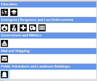
From those 10 things they only want the basics: category, name, address, and how you determined it is what it is. Did you see it, find it on a website, or knew someone who knows? Overall it’s simple. It’s great. It’s a good thing to do currently. So if you’ve never crowd sourced any information – here is your chance. Their is a peer review process currently. You will notice your icons change colors as they are reviewed. So they just aren’t turning you loose with no oversight. The oversight appears to be more guided than the Google Maps peer review process….or as I have called it….oh – I can’t use that term up here.
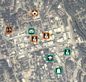 So I immediately started editing. Immediately wondered how I can make this better and I remembered Fulcrum. We’ve had an account post USVI and I decided to put it to use. Given the number of places I go It would be nice to just pull my phone out and record some information about the 10 features the National Map Corps want you to collect. I’ll most likely pull it into QGIS/ArcGIS and use that to guide some of my edits back into the map. I’ve already updated it 2 or 3 times. I even recorded a cemetery down the street from me as a test.

So – I’m going to make the pitch. If you’ve wanted to edit in OSM and have gotten frustrated or have just wondered if you are doing any good – Well – take a break and go over the the National Map Corps. You don’t need an app – all you need is pen, paper, and the ability to click on a map and fill out some information.There’s no reason you can’t make an account and make one edit. Maybe two.
Do something cool. Help.


