QGIS 2.12 is out and I’ve been a bit quiet as I’ve been exploring it as well as working with it.
As my proficiency with these open source mapping tools grow, I’m starting to learn some QA/QC (quality assurance/quality control) methods for checking data. If data resides in postgis I’m slowly building out tools for attribution and geometry and I’m doing the same with GRASS and QGIS.
Somewhere it seems around 2.2 (I may be wrong) a topology plugin appeared. For those of you familiar with the way ArcGIS Topology works you can go in and flag and fix problems with your data. There’s a large PDF suitable for framing on the ArcGIS Site to tell you everything it can do. I like the Topology checks in ArcGIS – you find errors and you fix them. The only problem I had with the tool it was a license level tool – those of you who bought arcview couldn’t use it. The QGIS Topology tool came along and while it wasn’t as robust as ArcGIS – you had a tool for your data to at least flag (there is no automatic fix built in yet) errors.
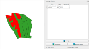
So this very innocent looking data layer has at least two problems (four total but I only checked for invalid topology and overlapping geometry)
Running QGIS Topology Checks:
There’s another tool with 2.12 that has been introduced – the Check Geometries Plugin. Once again – if you are familiar with the ArcGIS topology tools this won’t feel foreign at all.
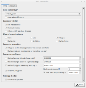
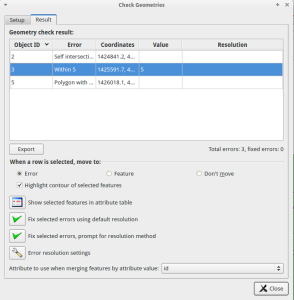
So this tool (you need to activate it under the Plugins Menu) gives you a chance to check your data and FIX IT AUTOMATICALLY. It can check for sliver polygons, data that self intersects, data that may not match a minimal mapping unit, and duplicated data (and more). It checks for errors in a different manner than the topology tool. If I run this against my dataset I can find at least three problems. I attempted to set up the exact same checks I used with the Topology plugin plus one more check for holes or gaps:
Once you find a problem you can move around automatically and fix either manually or automatically the problems. I’ve been playing with it and I haven’t decided on a methodology yet for using the two in a complimentary fashion – there may not be one. Between these two tools you almost have the ArcGIS Topology tool in QGIS though. I would strongly suggest playing around with it for a bit before you throw it into a production environment.
The bad – and I hate to say that this is even bad – It’s just different. These two tools really work independently of each other. So you’re going to be tempted (speaking to the former ArcGIS users) to use them both like they are a connected piece of software (notice I said above I’m attempting to work out a methodology to use them together because it’s too tempting). If I use both tools to look for all the errors in this layer the topology tool wins with 4 total errors while the geometry tool finds 3 errors (I built the dataset with 4 errors). The geometry tool does check for minimum mapping sizes and that’s something the topology tool doesn’t do. With another dataset it incorrectly flagged some geometry as errors that weren’t. Don’t worry – Bug report was submitted. It may not even be a bug but it doesn’t hurt.
Overall – check geometries is a welcome addition. You just need to be aware it’s different from the Topology tool. With the Check Geometries tool being “brand new” (so to speak) I would expect changes as feed back starts coming back into the QGIS project.
Back when I was 17 I bought a jeep. At 17 I thought it was the sexiest thing ever – most everyone else had determined I was driving my future coffin. I ended up at my Uncle’s house and I had been working on every part of the car that seemed to have problems. With a stethoscope, a hammer, a few electrical checking gadgets he found about three more problems I had completely missed. I was bummed. “I wished you weren’t finding problems with my jeep”. To which he pointed out “I’m not making more problems – just finding the ones that exist.” You now have more tools in you Desktop GIS to find errors and make clean data.


