
How did I end with this blog post. I’m using QGIS for about 90% of my GIS work these days and I spent about 6 hours digitizing some fairly complicated land cover. Out of that – you get the following…..
It was always one of the things that was hard to explain to someone brand new to GIS: ArcGIS has two clip tools.
- One tool clips one data layer against another. Example: Clipping all the roads to a county boundary.
- One tool clips a polygon layer based on some sort of input be it a line or polygon. It’s found under the Editor Menu on the editor Toolbar.
If I run into one problem when cleaning up data is polygon overlap. Someone will draw a polygon and then draw another either over it of overlapping it. In classes and with clients I always tell them “Imagine the world is flat like a pancake. In order to get polygon 2 “into” polygon 1 you have to clip/remove that overlapping portion with the editor tool”.
Example:

You have a polygon

You add a second polygon partially occluding the first

You initiate the clip tool on your editor toolbar
If I remove the second polygon you can see how the first polygon has been clipped
So where is the clipping tool in QGIS? Well…..there is a duplicate geoprocessing clipping tool. There isn’t a “editing” clip tool built into the core of qgis. Except there are ways of “clipping” that will accomplish the same feat in slightly different ways.
- If you are digitizing polygons and you want to digitize an interior polygon (lets say put a body of water in a field) you can use the “fill ring” tool to digitize and it instantly clips the big polygon to fit the small polygon. It is found on the Digitizing Toolbar.
- Clipper plugin. Select the smaller polygon and click the clipper button and it clips.
- There is another plugin called Digitizing Tools. If you do any amount of digitizing in QGIS I put this one up there with “Needed”.

It splits multipolygons. It does all sorts of Trickery with your digitized lines…..and it also clips. It clips against a different layer. A while back I talked about Memory Layers and Scratch Layers. Well – before I found the clipper plugin I was copying data into memory and running “Cut Polygon with another layer”. Lets say you have multiple polygons that you want to clip against the big one.
- Select and Copy them into a Memory Layer
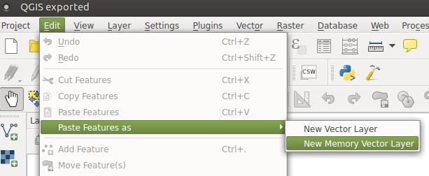
- Delete them out of the original layer
- Run “Cut polygon with another layer” and that other layer will be the memory layer (defauly layer name is Pasted).
- Copy and Paste them back in if that’s the end goal.
Example:

BEFORE

After Digitizing Tools
Would I want to do this on lots and lots of features? No. This is for digitizing and not geoprocessing and clipping thousands of things against thousands of other things.
Clipper might be able to do this though. The few times I tried I created topology issues so clipper has been to just clip one thing against one other thing. I have always like the clip tool with ArcGIS but it can only run one polygon at once. Is the QGIS way better? Not necessarily. Is the ArcGIS way better? No – it’s just more familiar. Which ever software is your weapon of choice you can do the same feats of GIS trickery.
Is Desktop GIS dead? I still say No.




