It’s been about a year since this project “appeared” and it was first done in ArcGIS. It wasn’t much fun (not because of ArcGIS). The part that made it “not fun” was the “Oh by the ways”. NRGS would deliver a map and get “Oh by the way can you add the acres for each tree type per property boundary”. OK fixed “Hey – Oh By the way we need only one property per map”. OK. “Ohhhh by the way can you make that yellow a purple”. &^%$*#
So anyway, the best thing in the world is ESRI’s data driven pages. You can set up one map and there’s enough flexibility to churn out a pile of PDF maps. In QGIS you have Atlas – and that’s almost a perfect drop in replacement.
I decided to do a test run on the map. I probably should have done that before spending a ton of time on the template. Luckily this time I know what needs to be done. These things need to be put on a map and they are attribute driven data:
- Tract Name
- Tract Number
- Property Name
- Acres of the Tract
- Summary of Acres Per Tract
I made a decision to use the Tract layer (technically a view – but that is coming up later). I set up that layer as an Atlas.
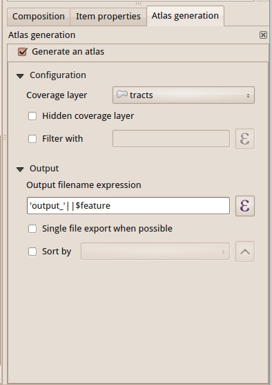
The test run was a bit easier than I thought. The tract Name, Tract Number, Property Name, and Acres are all contained in one of the layers. With Atlas (and Data Drive Pages) you can insert expressions. The expressions are fields from your data. See Screenshot:
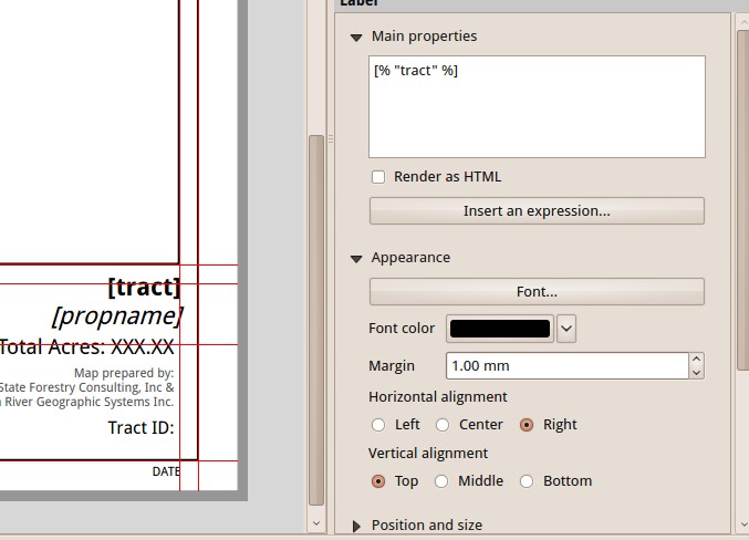
So when you preview this in Atlas (excuse the selection box):

With a few expressions I can start filling out parts of my composition……and I hit a problem. Hence the test run.
- For the sake of simplicity I need to only show one property per map. If you were to view the data you would find that some property is adjacent to other property and there’s not a clean way in either landscape or portrait or with scale to make a property appear by itself on a map.
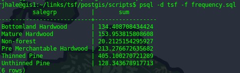
- I need to autogenerate acres for each property. There are ways to do this in QGIS…but I don’t want to hand modify each map. There are ways to generate this data in Postgis/Postgres:
So I think we’re halfway there. I’ve got a plan to fix the two problems. There will be some scripts written. Some database “things” done. Stay tuned.


