I’ve been slowly pushing QGIS 2.0 into my life as it gets closer to release – so here’s a little something that is actually very exciting and a great addition to QGIS 2.0 – Topology.
Now this doesn’t work quite like topology does in ArcGIS (yet) but considering it works with shapefiles (and no – I haven’t tried this in PostGIS yet) that’s pretty big. I consider the topology check in to be a work in progress – it will allow you to clean up your data in a way that hasn’t really been available with shapefiles (but there are tools in OpenJump to help with QAQC).
So lets look at this example:
This example comes from an often used dataset in all of my classes. Your intern Randy has been hard at work fixing your data while you are on vacation. You pop open a shapefile and visually everything looks good.
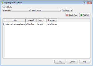
You decided to check the data and you pop open QGIS and turn on the topology checker. You build a rule to quickly check and see if he’s actually duplicated any polygons or done something to otherwise mess up your pristine data set.
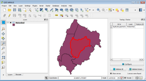
You validate the rule and:
You show a duplicated polygon. You check the data and yes you have a duplicated watershed. This is pretty cool because – you are running topology checks on shapefiles. Yes you have this ability in PostGIS and you have this ability with ArcINFO and ArcEditor (I know – I’m not calling them by their new names) if your data is in a geodatabase. So for the pile of users out there who are still keeping all their data in shapefiles – you have another QAQC tool to help you out thanks to the QGIS community. So if your dataset is pipelines, or houses, or utility infrastructure and you don’t have the ability to check to make sure you don’t have gaps in your data…or manholes are where they should be – you do now.
My only complaint – so far you get a visual check but you aren’t prompted for a fix. The offending data isn’t selected and you should have that ability. You probably will at some point very soon because I’ve been watching the developers email list and there is talk. I may not be understanding all that is being talked about…but they are on the right track.
So let me say this one more time: Topology checks for shapefiles.


